
Cabeza de Condor, or, “Head of the Condor,” the most prominent peak in the Condoriri Group as seen from the approach
The winter and spring in the Sierra Nevada were exceptional for a skier this year, and though the snowy exploration was quite memorable, any outdoor enthusiast risks holding on too tight – indulging so much that the love irrevocably fades. The trick is to heed temptation just enough for peak satisfaction, and to let go at the denouement, or at least before things get bad or unsavory. Great tours happened solo and with friends new and old, but by the time Memorial Day came around, it was time to leave, to do something different, as the standard routine of waking up early, stuffing feet into cramped ski boots for a long day in the hills began to lose its luster. A friendly reminder that first world problems are not problems, and yes, there was quite a bit of work done in between ski outings, but on the whole, it was necessary to mix things up – to break up what became the status quo in favor of something different – both location and activity.
Good thing Jeff and I planned another escape to South America for some climbing in a new area to us both: Bolivia’s Cordillera Real. Leave the skis at home in favor of ice screws, tools, pickets, fancy Italian shoes and various climbing ropes, time for a new location, a new range and different ways to enjoy these hills.
Pequeno Alpamayo’s summit with a 6’4” Swedish model in the foreground for scale
First, one needs to get there. Flying to La Paz meant at least 25 hours of travel for both of us, with mine having a 12 hour layover in Colombia’s Capital, Bogota. Rather than wait it out at the airport terminal, Uber made any lazy excuse unacceptable, and it was off to downtown for a few hours of sightseeing to break up the time in pressurized tubes cruising the troposphere. Now, I had heard of Simon Bolivar before, but it really brought things together to sip a latte on the edge of Plaza Bolivar, staring at a mounted bronze impression of him in one of the oldest parts of the city to gain an appreciation for who he was, his influence on the area and on the psyche of the inhabitants.
Known throughout South America as “El Libertador,” or “The Liberator,” the man’s name adorns our destination country, so it added some color to understand his impact on the continent, and more interesting still when Jeffrey and I would later travel through areas of victorious battles he waged in his efforts to free the continent’s indigenous and mestizo denizens from colonial rule. Any visitor to Bolivia is encouraged to read a little of this history and of the surrounding countries before making the trek, if nothing else than to get some color for how things unfolded to yield the present situation throughout South America. Bolivia itself holds the dubious distinction of being the poorest country in South America, and the place where other eclectic bits of history occurred - where Pinkerton and his gang finally cornered Butch Cassidy and the Sundance Kid and where more gold and silver were extracted in a matter of years than in the entirety of European history, to name just two.
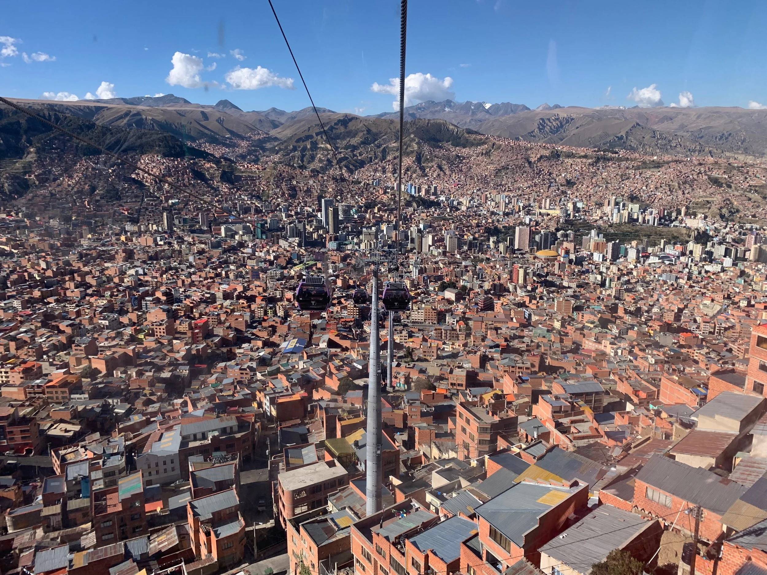
A view of La Paz from its subway in the sky - La Morada line on the Mi Teleferico
With history as a foundation, it was on to nearly three weeks of exploring and rambling in the mountains for myself and the Swedish model to whom I’m spasmodically tethered by climbing ropes. Jeffrey did an excellent detailed recap of our five climbs in the country during that time so the reader is advised to ingest his written word for the minutia. On this end, the bigger themes are what resonate in the days and weeks following our travels in the country, so they are offered below.

Cloud dancing at the base of Huanya Potosi before a summit bid on the French Route, or “Chicken the French.” See the video through…patience is a virtue
The first impression that continues to resonate is the dramatic landscape Bolivia provides to any visitor. Its capitol city – and base camp for our stay – is La Paz, a city originally founded in the mid sixteenth century, and presents a most improbable image of a city painted on the walls of a canyon at nearly 12k feet of elevation. From the city center – the Prado – to the upper edge of the canyon represents 1500 feet of vertical gain, with clay-brick dwellings canvassing nearly every visible area of the terrain, and best experienced by riding one of the nine gondola lines substituting the modern subway.
To the west of the city, the Bolivian altiplano, or ‘high plains,’ a very flat, seemingly desolate area resting above 4km. To the east, a stretch of the Andes referred to as the Cordillera Real, with the most prominent peaks cresting 6000m. During the Austral winter – the best time for climbing in the country because of the stable weather, relative warmth and freedom from precipitation – the altiplano is chilly and dry, and though we found the mountains periodically [and dramatically] speckled with cloud cover spilling over from the Amazon, the snowfall is over for the season, and an abrupt interface occurs where rock meets glacier at the higher elevations. Excellent for fast approaches, easy route finding and more straightforward logistics.
The Condoriri group from Lago Chiar Khota
And the roads…sure, there is pavement on the main highway snaking up the western part of the country, but even it had ubiquitous rough sections and even speed bumps as it wove through local townships. Nearly all the roads in La Paz required asphalt or concrete, for due to the geology - everything we saw was a motley mix of conglomerate as if the entire area was a giant glacial moraine left over from the latest ice age – unless they were paved with modern techniques they were vulnerable to wash out upon even the least amount of rain.
Huanya Potosi being touched by Dawn, with her fingertips of rose
Beyond the city limits, reaching remote mining and subsistence farming towns is where things get really interesting. Steep, gnarly switchbacks on single-lane dirt causeways demand attention as the roads go over the most improbable passes and to the most inconceivable destinations. It’s a stimulating day to sit and watch where the coca-leaf chewing taxi or collectivo driver takes you en route to your final destination – just don’t complain when at the end of the drive, you have a nice film of dust covering everything unsealed from the elements.
It was at that point where I began to understand the allure many have of driving a properly equipped adventure motorcycle from Canada to Tierra del Fuego and getting [temporarily] lost on those paths. Seldom – if ever – will you see another gringo, and seeing this snapshot from another era, and another culture seems like an unforgettable way to spend a vacation. Sure, there is a periodic power line that crosses your periphery, and an occasional collectivo taking some locals to and from the closest settlement, but beyond that, it’s almost as if you and Doc Brown took the DeLorean back to the days of the Spanish conquistadors – to a time when things were more simple, slower and tangible.
Another greater theme that played out during our stay stemmed from one of the many conversations in approaching mountains there, where the concepts of Optimism Bias and Reference Class Forecasting were discussed in relation to professional pursuits and modern sociological theory. Quickly and organically, these ideas were applied to the objectives at hand: mountains and the requisite planning and execution of attaining their summits.
They represent a great pair of contrasting ideologies: The former being how one thinks [in error] they are less likely to experience a negative event. The latter, how to use previous experiences to predict future outcomes. Humans are [healthily] prone to be optimists, but to keep that optimism in check, it’s necessary to use our experiences and those of our peers and colleagues to prevent failure in future pursuits.
Jeffrey, taking a breather before tackling the final summit ridge on Huanya Potosi’s French Route - The mountain’s name loosely translates to “Thunderous Youth”
The formula is simple: leverage satellite communications | postpone taxi whilst chatting with your betrothed | climb that rather impressive-looking mountain back there
After two days of acclimatizing at La Paz’s 4000m elevation, we got a leisurely departure from La Paz and were making headway to the Condoriri basecamp on the gorgeous, light duty trail when the proposal was struck: why not forego the standard formulaic approach to our first objective, with its inch-worm strategy and ‘alpine start’ and just summit from the trailhead? We debated back and forth about the cost/benefit of dropping our over-night gear and gunning for it, and given our assessment of risk, conditions, fitness and navigation, it made sense to give it a go.
Four hours later, and after a wonderfully exposed yet stable and consistent crux summit ridge, we were already celebrating our first cumbre. There was still plenty of daylight to down-climb the more difficult steep snow and ice sections, as well as the 3rd and 4th class rock, and we even passed the last of the glacier to our trailrunners before head lamps were compulsory. Sure, by the time we stumbled into camp, we were knackered and dehydrated from a more ambitious acclimatization introduction to the range, but it was totally worth the effort up front to get the summit to ourselves in the golden hour, with amazonian cloud dancing accompanied for dramatic effect.
Huanya Potosi’s Summit Ridge after the French Route, with the earth seemingly falling away to the cloud-cloaked Amazon Basin below
With two more days until our scheduled taxi at the trailhead, we debated the merits of attempting the crown jewel of that part of the Range: the Cabeza de Condor. After some reconnaissance on the approach, and a sound discussion on how to best address our lack of route knowledge and gear planning, we shared a wonderful day of progressing steadily to the summit. Knowing the pace at which we moved, the conditions and other potential safety risks, we decided to buck the early trend again to be the ‘second shift’ on the mountain and start later. It worked out smoothly, and Jeffrey even had a chance to sleep off “one of those days” with a brief but fulfilling siesta before skipping past llamas, alpaca, and donkeys down to meet our taxi in the pamapas below.
Technology making travel profoundly easier and amusing
“I need the road work.” Playing chicken on a one-lane road with a diesel-belching bulldozer making the annual maintenance in the hills above Sorata
The same forecasting applied to what was next on the trip: Huanya Potosi. Considered by many to be the ‘easiest’ 6km peak in the world, there are more challenging ways to the summit than the standard cattle trail, and after some research and discussions with locals it made more sense to first avoid the effort of setting a high camp and instead fire the mountain from the road, but also to choose a more challenging path to the summit: the French route, or, after a rather humorous google translation of the previous night’s entre, “Chicken the French.”
And what another enjoyable outing. Sure, there was an even more technical ascent on the west face, but it didn’t strike our fancy, and moving more efficiently with lighter packs, and starting later from a lower elevation provided another ‘second shift’ experience, where we barely saw another party on what is considered to be the most crowded peak in the country.
At risk of sounding like a broken record, the same ‘reference class forecasting’ played out for the remaining mountains on our trip: for both Illampu and Illimani, it made little sense to us to engage in uncomfortable alpine starts when the risk of snow bridges collapsing or wet slide avalanches were minimal. And so it went…later, slightly more casual starts for bigger peaks became the norm - we slept more, were warmer on ascents and ran into fewer people whilst not compromising safety.
Finally warm just below the summit ridge at 21k feet on Illampu…cause for the first smiles in seven hours of movement
A bigger theme to consider is that of gratitude. It doesn’t take long traveling in any of the world’s developing nations to understand how lucky we are as US citizens. By the very fact that we’re wealthy enough to even travel to these countries on a paid vacation speaks for itself, let alone getting to experience these cultures first hand – seeing how we shouldn’t take for granted the clean air we breath, the clean water we drink and the reliability of our utilities that we love to lambast the moment there’s a blip in our service. One walk through the markets – with their open air slaughterhouses, unrefrigerated meats and profound lack of sanitation was enough of a reminder for the author to never complain about American supermarkets ever again.
The views from the collectivo included 13k vertical feet, from Eucalyptus-clad valley surrounding Sorata to the 21k’ summits of the Ancohuma massif. Photo: Jeff Hebert
Then it’s walking the streets, where busses and trucks continually spew black clouds of diesel exhaust into the pedestrian pathways – it’s always a surprise to think that the Clean Air Act was pushed through by Nixon and his republican administration, and how thankful we should all be that the EPA exists in our home country [albeit continually under siege from the right and other special interests]. Back in our La Paz dwelling, reading about the municipal water supply, we were advised to drink bottled water due to microbes and heavy metals persistent in the chain. This leaves any visitor skeptical of fresh fruits or vegetables consumed in restaurants along with the ethical tension of generating quite a bit of plastic waste in an area where recycling isn’t even a word. The river flowing through the center of the city was perhaps the most putrid smelling body of water the author has ever experienced, and was like a time warp to the Cuyahoga River in 1969. Anecdotal journalism in La Paz pinned the figure of at least one ton of heavy metals being dumped into that river every day at the hands of surrounding mining and industry.
Precarious still is the source of their actual drinking water. The glaciers are receding quickly in the Cordillera, and though still large, they pale in comparison to their former selves just 20 years ago. When they’re gone, so too is the drinking water for inhabitants of Bolivia west of the Range. There was the recent story of Cape Town’s water problems, and now India in 2019…I’m worried for Bolivia and its citizens when these glaciers start disappearing sooner than scientists thought.
Mentioned previously are the roads: Americans love to complain about traffic and potholes, so it’s nice to re-calibrate, to see how less organized countries move their people and goods throughout the land and to gain a renewed appreciation for the Eisenhower Interstate System and the vast supporting network of civil-engineered causeways so many of us take for granted.
“Travel is fatal to prejudice, bigotry, and narrow-mindedness, and many of our people need it sorely on these accounts. Broad, wholesome, charitable views of men and things cannot be acquired by vegetating in one little corner of the earth all one’s lifetime.”
“You don’t know the value of water until the well runs dry,” the sign reads above the local Sorata child with his mum…whom we figured was either trying to short sell some Tesla stock on her e*trade app, or swipe left on Tinder. We never found out.
Quite apropos to our stated intent of visiting the country, the travel afforded a gratitude of the outdoors, our national and state parks, and even public green places free of feral dogs, waste and pigeons. The stateside ‘leave no trace’ ethic, though imperfect and often violated, is still something to celebrated and expanded. Nearly every trail, base- and high-camp we visited was heavily compromised by discarded single use plastic bottles, wrappers, human waste and plagued by general misuse. It’s easy to scoff at trailhead quotas and the need to attain permits to access our public lands in the United States, but that’s a critical hurdle to educate visitors as to proper behavior to keep these places as pristine as possible whilst simultaneously allowing us to explore their beauty.
It was wonderful not to have to worry about red tape when approaching our desired objectives, but we were left to question how to properly dispose of our waste [besides the standard pack-in, pack-out ethic] and lacked local protocol for preserving the area. This gave the sentiment of a free-for-all, and though we were cautious visitors, it certainly leaves the door open for less scrupulous consumers of natural resources who care little for those who come after them expecting some amount of conservation and respect. For the major peaks, we were obligated to pay an ‘entry fee’ for use of the trails, though its collectors were as was suspicious as the thought of where those funds actually landed after fleeing our billfolds.
Lastly, a critical theme was something that started in the very planning of the trip in the first place: being forthright with desires, abilities, fitness and knowledge, and making decisions accordingly. In early 2019, options for what to do with vacation were vast, with two major ideas rising to the fore: a European getaway to the Alps which would inevitably involve a more civilized set of outings set in the old world where creature comforts and luxuries abound, or ‘roughing it’ a little, exposing ourselves to a more edgy part of the world, and getting a little further off the beaten path. Huanya Potosi notwithstanding, the mountains of the Cordillera Real are far less trodden than the Glaciers off the Aiguille du Midi, and having most recently pampered ourselves in New Zealand with more vineyards than mountains, helicopter approaches and posh, english-speaking, developed-world accommodations, there was more enthusiasm for sights less known. Bolivia it was.


That same candidness played out multiple times during the trip: adding on Cabeza de Condor after it wasn’t originally on the itinerary [and because it was particularly inspiring], summiting Huanya Potosi third for additional acclimatization, and throwing out a mountain originally on the list [Ancohuma] because the routes to the summit were less rousing, and because the logistics were more involved and less savory.
Finishing off the summit ridge to Illimani’s Pico Sur with the rest of the ridgline to the north and central peaks visible behind
The most logical climbing line on Illimani – the mountain looming over La Paz much like Tahoma looms above Seattle – is to complete the three peaks traverse [Norte, Central and Sur]. After much planning, it was to be our culminating experience of the trip, but after weighing everything we experienced on similar climbs thus far, objective hazards known on route, feeling the cumulative time at elevation with ‘heavy’ packs, and at least one of us having his biome disrupted by the local microbes, we had a candid chat and decided on a more conservative path – the standard route to the summit. Sure, it wasn’t very technical, but high camp provided an incredible setting, and just getting there was a memorable glimpse into Bolivia’s unique character. After the grinding, vertically efficient approach, it was mutually decided that the best decision was made, representing a most practical response to real circumstances.
El Libertador and his namesake country liberated us both from our respective quotidian, leading us to explore new mountains, new people, new terrain and now the images and experiences of Bolivia remain indelible. Knowing the results of our previous outings helped shape better outcomes, with old meeting new to make the logistics, approaches and summits safer, easier and better attained. With five peaks covered in three weeks, countless empanadas, and kilometers logged through a most dramatic landscape, whether or not we return to the area is questionable, but whether or not we forget what we saw and experienced is not up for debate. Lastly, a poem that resonated throughout the winter surfaced again during our many miles on the trail. Perhaps America’s mostly widely misunderstood literary sensation, much of its themes played out before, during and after our trip, and it’s worth inclusion for posterity, and the reader is encouraged to understand why it’s so misunderstood…
“Two roads diverged in a yellow wood,
And sorry I could not travel both
And be one traveler, long I stood
And looked down one as far as I could
To where it bent in the undergrowth;
Then took the other, as just as fair,
And having perhaps the better claim,
Because it was grassy and wanted wear;
Though as for that the passing there
Had worn them really about the same,
And both that morning equally lay
In leaves no step had trodden black.
Oh, I kept the first for another day!
Yet knowing how way leads on to way,
I doubted if I should ever come back.
I shall be telling this with a sigh
Somewhere ages and ages hence:
Two roads diverged in a wood, and I—
I took the one less traveled by,
And that has made all the difference.”
The Swedish model at Illimani’s 18k’ high camp, more fittingly referred to as “The Condor’s Nest”